Information in the Emergency and Medical Services page of this website may also be of interest.
An alternative way to look at the Disaster Preparedness information in this page of this website is to view this pdf:
Welcome
Welcome to the Disaster Preparedness and Recovery webpage. The Town of Woodstock, in conjunction with Cornell Cooperative Extension (CCE) Ulster County ulster.cce.cornell.edu/ and the Ashokan Watershed Stream Management Program ashokanstreams.org/, has developed a bank of resources to help prepare yourself, your family, your neighborhood, and your community.
As the impacts of climate change intensify, it is evident that disasters don't plan ahead, but you can! Disasters can occur unexpectedly and have devastating consequences for individuals and communities. In these situations, it is crucial to have a plan in place to minimize the impact of the disaster and recover as quickly as possible.
This webpage provides resources and information to help you prepare for disasters and emergencies. It covers a range of topics, from developing a family emergency plan to the multi-faceted relationship between climate change and natural disasters. We provide information on what to do during and after a disaster, including how to access emergency services and how to start the recovery process.
Our goal is to empower individuals and communities to take proactive steps to reduce the impact of disasters and emergencies. By preparing in advance, we can better protect ourselves, our families, and our communities. We encourage you to explore the resources available on this webpage and take the necessary steps to be prepared for the unexpected.
Stay Informed
Community Notification System
Local:
When an emergency strikes, it's important to be in the know. For access to urgent alerts, visit the Town of Woodstock home page woodstockny.gov to view public notices or connect on Facebook to view updates that may be related to weather events and more during an emergency.
Radio Kingston radiokingston.org/en/ (WKNY 1490AM and 107.9FM) is a local radio station, designed to stay on the air in all manners of disasters, with solar power, battery backup, and generators. Their infrastructure is purposefully designed to be resilient in all situations. Tune in all hours of the day and night to get updates during emergencies.
County:
The Integrated Public Alert & Warning System (IPAWS) is FEMA's national system for local alerting that Ulster County can access and use. IPAWS can assist in providing authenticated emergency and life-saving information to the public through mobile phones using Wireless Emergency Alerts, to radio and television via the Emergency Alert System, and on the National Oceanic and Atmospheric Administration's (NOAA) Weather Radio when there is a disaster or emergency incident that warrants public notification.
To learn more about IPAWS, visit fema.gov/emergency-managers/practitioners/integrated-public-alert-warning-system/public.
State:
New Yorkers can subscribe to NY-Alert alert.ny.gov/sign-up-ny-alert to receive critical information and emergency alerts on what is happening in their area. NY-Alert alert.ny.gov/ contains critical, emergency-related information including instructions and recommendations in real-time by emergency personnel. Information may include severe weather warnings, significant highway closures, hazardous material spills, and other emergency conditions.
All areas of New York State are included in the system, and you can decide which area you would like to receive alerts about.
Stream Gage Monitoring and River Forecast
The New York Extension Disaster Education Network (NY EDEN) eden.cce.cornell.edu/ is a collaborative educational network based at Cornell University and dedicated to educating New York residents about preventing, preparing for, and recovering from emergencies and disasters. Utilizing an aggregated collection of research-based guidelines and best practices aggregated from across the national Extension network, NY EDEN provides communication outreach on these critical and timely subjects through this website (eden.cce.cornell.edu) as well as its Facebook facebook.com/CCE.NY.EDEN/ and Twitter x.com/CCE_Disaster social media channels.
NY EDEN is affiliated with the national USDA Extension Disaster Education Network (EDEN) extensiondisaster.net/. EDEN is a national organization of land-grant universities that links Extension educators from across the United States and throughout various disciplines, enabling them to develop and use resources to reduce the impact of disasters.
Road Closures
Please visit the Ulster County Department of Emergency Services webpage on updated road closure information experience.arcgis.com/experience/e718984e01af4f008555701b8776f2da. The list includes locations where the roads are shut down, or traffic is currently being affected due to traffic hazards or weather. This list is constantly changing. The county will provide updates to this list throughout the day.
Stream gages are stream monitoring devices that measure and report near real-time stream conditions including water level, or “stage”. Stream gages provide important data relating to residents and the safety of their homes. There are not any stream gages in the town of Woodstock. However, the Beaver Kill at Mount Tremper NY waterdata.usgs.gov/monitoring-location/USGS-01362487/#period=P7D&dataTypeId=continuous-00065-0&showFieldMeasurements=true and Little Beaver Kill at Beechford waterdata.usgs.gov/monitoring-location/USGS-01362497/#period=P7D&dataTypeId=continuous-00065-0&showFieldMeasurements=true stream gages collect data from streams whose headwaters are in Woodstock. These gages provide the best available insight into local stream conditions within the Town.
Emergency management and services personnel, as well as citizens, can access daily water level readings from the following websites:
Use this interactive map dashboard.waterdata.usgs.gov/app/nwd/en/?region=lower48&aoi=default from the United States Geological Survey (USGS) National Water Dashboard to explore stream gages across the country that display a range of stream information including discharge, turbidity, and more.
The USGS Mobile Water Data site waterdata.usgs.gov/nwis/rt highlights USGS current conditions water data across the United States in a mobile-friendly website, allowing users to monitor conditions at a favorite river or stream outside of the Town or locate other regional monitoring locations.
Below are tables showing highest recorded gage heights (height of streams) at the two gages within the Town of Woodstock in recent years. If you lived in the area, you may remember what the stream looked like at your property during these events. The files with the Table 1 and Table 2 data are attached, in addition to the images being included.
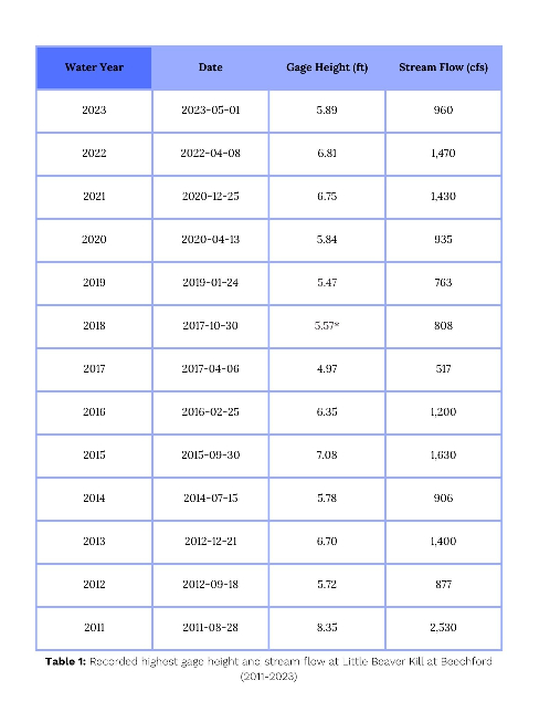
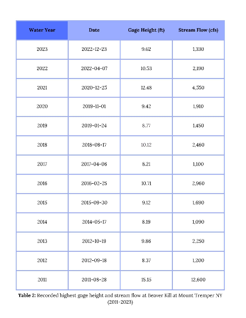
Note that your local conditions may vary considerably from stream conditions at either gage considering both gages are several miles downstream from Woodstock. However, it can still be useful to monitor the nearest gage during high flow events and roughly correlate gage height readings to visual observations of stream conditions within the Town.
National Weather Service Advanced Hydraulic Prediction Service
You can also visit the National Weather Service (NWS) National Water Prediction Service (NWPS) webpage drought.gov/data-maps-tools/national-water-prediction-service-nwps-river-gauge-observationsforecasts-and-flood#:~:text=The%20National%20Weather%20Service%20(NWS,%2C%20Puerto%20Rico%2C%20and%20Alaska. for river forecast reports that predict stream level over the next 24 hours. River forecasts are available for the Esopus Creek at Mount Marion water.noaa.gov/gauges/mrnn6 and Esopus Creek at Coldbrook water.noaa.gov/gauges/mtrn6. Although not located in the town of Woodstock, these two river forecast websites still provide valuable insight into the likelihood and severity of localized riverine flooding.
Access Resources
Emergency Assistance and Shelters
During an emergency or natural disaster, emergency shelters play a critical role in ensuring the safety, well-being, and survival of affected individuals and communities. These shelters provide a safe haven for those displaced or at risk, offering temporary refuge, basic necessities, and essential services. They offer protection from immediate threats, such as extreme weather conditions, and help mitigate the potential impact of the disaster on vulnerable populations. Emergency shelters also facilitate coordination and support from relief agencies, enabling the efficient distribution of food, water, medical assistance, and emotional support.
Residents are encouraged to check the Town of Woodstock home page woodstockny.gov or Facebook to confirm whether the Community Center will be used as an emergency shelter in the event of a disaster.
For access to information pertaining to Ulster County Emergency shelters, visit the Ulster County shelter and center page ulstercountyny.gov/emergency-services/warming-centers. The site will be updated when a shelter or center is opened in Ulster County.
You can also visit the Red Cross Shelter Map redcross.org/get-help/disaster-relief-and-recovery-services/find-an-open-shelter.html to discover open shelters that are operated by the Red Cross or partner agencies.
Warming and Cooling Centers
Warming Center:
Extreme cold weather events such as blizzards are becoming more likely in the Northeast and are predicted to increase in intensity despite rising temperatures and shortened winters. Warming centers can ensure your safety and prevent exposure to dangerous and inclement weather.
Residents are encouraged to check the Town of Woodstock webpage woodstockny.gov or Facebook to confirm whether the Town Hall or Community Center will be used as a warming center during an extreme weather event.
County:
Law Enforcement agencies or any other organizations that come in contact with or become aware of any individuals that need shelter can bring them to the warming center. Warming Centers openings will be announced by the Ulster County Department of Emergency Services.
For up-to-date information on county-operated warming centers, visit the Ulster County Emergency Services webpage ulstercountyny.gov/Departments/Emergency-Services or check the Ulster County Facebook page facebook.com/UlsterNY for updates.
Cooling Center:
Planning for extreme heat is critical for ensuring the long-term resilience of a community and reducing the number of deaths and hospitalizations that occur during high-heat events. Cooling centers are air-conditioned spaces where the public can cool down. Air-conditioned libraries, supermarkets, and malls are great places in the community to get cool. Shaded areas of local and state parks or swimming facilities like community pools and beaches are also places you can go to get cool during the summer heat.
Residents are encouraged to check the Town of Woodstock webpage woodstockny.gov or Facebook to confirm whether the Town Hall or Community Center will be used as a cooling center during an extreme weather event.
County:
Law Enforcement agencies or any other organizations that come in contact with or become aware of any individuals that need shelter can bring them to the warming center. Cooling Center openings will be announced when there are 3 or more consecutive days above 90 degrees.
For up-to-date information on county-operated cooling centers, visit the Ulster County Emergency Services webpage ulstercountyny.gov/Departments/Emergency-Services or check the Ulster County Facebook page facebook.com/UlsterNY for updates.
Food Pantries
During and after an emergency, residents are encouraged to utilize food pantries. These resources play a vital role in providing essential nourishment to individuals and families facing food insecurity during challenging times. Food pantries help bridge the gap when access to regular food supplies is disrupted or limited due to emergencies such as natural disasters. They offer a lifeline by distributing donated food items and groceries to those in need, ensuring that nobody goes hungry.
Reference this map google.com/maps/d/viewer?source=embed&hl=en&geocode&aq&ie=UTF8&hq=new%20visions%20health%20project%20hunger&hnear&oe=UTF8&msa=0&ll=41.789265743464874%2C-74.21470599999999&spn=0.689036%2C0.523224&mid=16fqlwbYGvPzLhPfmWJaASwlM2MU&z=9 to find which location is closest for you and how to get there via public transportation. Visit the UlsterCorps website ulstercorps.org/for-volunteers/opportunities-by-agency-type/food-pantries-and-meal-programs/ for an updated list of food pantries and relevant resources.
In the Town of Woodstock, you can visit the Good Neighbor Food Pantry goodneighborfoodpantry.org/.
You can also reference this map ulstercorps.org/wp-content/uploads/2022/05/UCAT-Pantries-11x17-may_2022.pdf of Ulster County Food Pantries, Meal Programs and UCAT bus lines, developed & maintained by UlsterCorps & Family of Woodstock. This map can also be found in this pdf file:
Food and Water Safety
In the event of an emergency or disaster, access to food, water, and electricity may be limited or scarce. Prepare for yourself and your family by storing emergency food and water supplies.
Food:
During an emergency situation, it's important to take steps to ensure that the food you consume is safe to eat. Here are some food safety and storage tips to follow during and after an emergency:
- Keep food at safe temperatures: Keep perishable foods such as meat, poultry, seafood, and dairy products refrigerated at a temperature below 40°F. If there is a power outage, try to keep the refrigerator and freezer doors closed as much as possible to maintain the cold temperature. Use a thermometer to check the temperature inside the refrigerator and freezer when power is restored.
- Use food within recommended timeframes: Check the expiration dates on your food items and use them within the recommended timeframe. If you are unsure whether a particular food is still safe to eat, use your senses to check for any unusual odors, colors, or textures.
- Store food properly: Keep food stored in airtight containers or packaging to prevent contamination from pests and bacteria. Avoid storing food near chemicals, cleaning supplies, or other hazardous materials.
- Use clean utensils and surfaces: During an emergency, it's important to use clean utensils and surfaces to prepare and handle food. Wash your hands frequently with soap and water, and use clean cutting boards, knives, and other utensils.
- Cook food thoroughly: Cook all meat, poultry, seafood, and eggs to the proper temperature to kill any harmful bacteria. Use a meat thermometer to ensure that the internal temperature of cooked food reaches at least 165°F.
- Use safe water: Use only safe, clean water for drinking, cooking, and cleaning. If you are unsure about the safety of your water supply, boil it for at least one minute before use.
- Discard any questionable food: If you suspect that any food may be contaminated, discard it immediately. Don't take any chances with food safety, especially during an emergency situation.
- Familiar foods are important and create a feeling of security in times of stress. Try to include foods that you and your family will enjoy and that are also high in calories and nutrition. Foods that require no refrigeration, water, special preparation, or cooking are best.
Find out more on how to keep food safe before, during, and after emergencies, such as floods, fires, natural disasters, or the loss of power foodsafety.gov/blog/avoid-foodborne-illness-during-temporary-power-outages by visiting Foodsafety.gov foodsafety.gov/.
For more questions about food safety fsis.usda.gov/food-safety, contact the USDA’s Meat and Poultry Hotline at 1-888-MPHotline (1-888-674-6854) to talk to a food safety expert or chat live at ask.usda.gov ask.usda.gov/s/ from 10 a.m. to 6 p.m. Eastern Time, Monday through Friday.
Water:
Water safety and storage are critical during an emergency. Here are some tips and resources to help you ensure that you have safe and clean drinking water before, during, and after an emergency:
Before:
- Store enough water: It's recommended to store at least 1 gallon of water per person per day for at least three days. Store water in clean, airtight containers, and label them with the date they were filled.
- Rotate stored water: If you're storing water for an extended period, rotate it every six months to keep it fresh.
- Learn how to purify water: Learn how to purify water in case your stored water runs out. Some methods for purifying water include boiling, using water purification tablets, and using a water filter.
- Locate emergency water sources: Identify sources of water that you can access in an emergency, such as a nearby lake, river, or well.
During:
- Use safe water sources: If your regular water supply is compromised, use your stored water or find a safe water source to use. Boil or treat any water from an unknown source before drinking it.
- Avoid contaminated water: Do not drink water that has a strange color, odor, or taste. Also, avoid water that may be contaminated by chemicals, sewage, or other hazardous materials.
- Collect and store rainwater: You can also collect rainwater during an emergency. Place a clean container outside to collect the rainwater.
After:
- Check for safety: Check with your local authorities to see if your water supply is safe to drink. Listen to news reports and follow any instructions from local officials.
- Purify water: If your water supply is not safe, use a water purification method to make it safe for consumption.
- Dispose of contaminated water: If you suspect that any water may be contaminated, do not use it for any purpose. Dispose of it properly.
Resources for food and water safety/storage:
- Cornell Cooperative Extension of Ulster County- Food Safety & Emergency Resources ulster.cce.cornell.edu/healthy-communities/food-and-nutrition/food-safety-emergency-resources
- Centers for Disease Control and Prevention (CDC) - Emergency Water Supply Preparation cdc.gov/water-emergency/about/how-to-create-and-store-an-emergency-water-supply.html?CDC_AAref_Val=https://www.cdc.gov/healthywater/emergency/creating-storing-emergency-water-supply.html
- Federal Emergency Management Agency (FEMA) - Water ready.gov/water
- American Red Cross - Water Storage redcross.org/content/dam/redcross/atg/PDF_s/Preparedness___Disaster_Recovery/Disaster_Preparedness/Food_Safety/Food_and_Water-English.revised_7-09.pdf
Electrical/Gas Outages & Water/Bagged Ice
Power outages may become more frequent with increased storm intensities due to climate change. Stay informed on outages by using the Central Hudson Interactive Outage Map outagemap.cenhud.com/?language=en-US. In the event of a gas-related emergency, call 911 to contact the local fire department. For information regarding electric and natural gas safety, visit https://www.cenhud.com/Safety cenhud.com/Safety.
In the event of an emergency, Central Hudson will also distribute dry ice and bottled water to customers in need.
Customers can stay informed of storm and restoration conditions in the following ways:
- By text messaging: Customers should enroll in Central Hudson’s Texting Program to use text messaging to report their power condition and to obtain repair status. To enroll, visit CentralHudson.com/Alerts cenhud.com/Alerts or text REG to 236483
- On the Web: Visit CentralHudson.com/Storms cenhud.com/Storms to report outages and obtain restoration updates
- Via smartphones: Updated free Central Hudson mobile applications are available for Android and Apple devices by logging onto www.cenhud.com/mobileapp cenhud.com/mobileapp.
- Through social media: “Like” Central Hudson on Facebook (Facebook.com/CentralHudson) facebook.com/centralhudson/ and “Follow” on Twitter (Twitter.com/CentralHudson) x.com/CentralHudson?ref_src=twsrc%5Egoogle%7Ctwcamp%5Eserp%7Ctwgr%5Eauthor
- By phone: Call the Central Hudson PowerLine at (845) 452-2700 or 1-800-527-2714, and please use the automated system to report or monitor your power condition.
- If a member of your household needs electricity to operate life-sustaining equipment, please contact customer service at (845) 452-2700.
Power Line Safety
Downed power lines can be extremely dangerous and can cause severe injury or death. Here is some detailed information and resources on how to stay safe when there are downed power lines after a storm:
- Stay away from downed power lines: Always assume that any downed power line is energized and dangerous. Stay at least 10 feet away from the downed line and anything that it may be touching.
- Avoid contact with anything in contact with the downed line: If a power line has fallen on a car, fence, or tree, avoid touching these objects as they may be energized.
- Never attempt to move a downed power line: Only trained professionals should handle downed power lines. If you see a downed power line, call your local power company or emergency services immediately.
- If you're in a vehicle that encounters a downed power line: Stay inside the vehicle and wait for help to arrive. If you must exit the vehicle, jump out with both feet together, landing on the ground without touching the vehicle and the ground at the same time. Shuffle away from the vehicle, always keeping your feet close together and on the ground.
- Report downed power lines: If you see a downed power line, report it to your local power company or emergency services immediately.
Additional Resources
- Central Hudson – Electrical Safety cenhud.com/en/my-energy/safety/electrical-safety/
- Electrical Safety Foundation International - Downed Power Lines esfi.org/downed-power-lines/#:~:text=If%20you%20see%20a%20downed,downed%20power%20lines%20are%20live.
- Centers for Disease Control and Prevention - Power Outages cdc.gov/disasters/poweroutage/needtoknow.html
- Ready.gov – Power Outages ready.gov/power-outages
Generator Safety
In the event of an electric failure, generators are typically used as a source of secondary power. Unfortunately, this emergency equipment can present serious health and safety concerns. The following information is sourced from the Occupational Safety and Health Administration (OSHA), Red Cross, and the Federal Emergency Management Agency (FEMA). The primary hazards that arise when using a generator include:
Carbon monoxide (CO) poisoning
- Never use a generator inside a closed space, including but not limited to, homes, garages, basements, crawlspaces, or any partially enclosed area.
- Ensure devices are outdoors and are kept away from doors, windows, and vents that could allow carbon monoxide to circulate indoors.
- CO cannot be seen or smelled, leading to incapacitation or death. Do not attempt to use fans, open doors, or windows to allow for air flow. Rather, if you begin to feel sick, dizzy, or weak – get to fresh air immediately and seek medical attention. Do not re-enter the area until it is determined to be safe by trained and properly equipped personnel.
- Install CO alarms in central locations within your home. Test batteries frequently and replace when necessary. Ensure alarms are located on every level and in close vicinity to sleeping areas to ensure proper warning of accumulating carbon monoxide.
Fire
- Generators increase in temperature while running and may remain hot even after they are stopped. Ensure proper cool off time before refueling, relocating the generator or placing objects nearby.
- Generator fuels (gasoline, kerosene, etc.) are flammable and will ignite when spilled on a hot engine part. All fuels should be stored in containers with proper designs, ventilation, and labeling for contents. Fuels should NOT be stored in the home.
Electrocution
- Always use heavy-duty extension cords when connecting a generator to other appliances.
- An increase in voltage or a surge to outside power lines can occur when hooking your generator directly into your home power supply. This action could lead to potential injuries or electrocution of utility linemen but may also bypass circuit protection devices, resulting in a surge of electricity leading to major injury or death.
Additional Resources
- Generator safety video (Includes American Sign Language (ASL) translation) youtube.com/watch?v=n7GIOzABRHA
- How to operate a generator dhses.ny.gov/generator#:~:text=Generator%20must%20be%20grounded%20properly,State%20Fire%20and%20Building%20Codes.
- CDC carbon monoxide video cdc.gov/carbon-monoxide/about/index.html or call 800-232-4636
Electric Car Charging Stations
In the event of an emergency, visit NYSERDA’s Electric Vehicle Station Locator nyserda.ny.gov/All-Programs/Drive-Clean-Rebate-For-Electric-Cars-Program/Charging-Options/Electric-Vehicle-Station-Locator#/find/nearest to find nearby electric charging station locations. The U.S. Department of Energy’s (DOE) Alternative Fuels Data Center (AFDC) provides up-to-date information on alternative fueling station locations.
Download the National Renewable Energy Laboratory’s mobile application available for Android play.google.com/store/apps/details?id=gov.energy.afdc.stationlocator&pli=1 and Apple apps.apple.com/us/app/alternative-fueling-stations/id718577947 devices.
Electric vehicle charging is available locally at the Rock City Rd. parking lot. For location information, please reference the map in the next section, Emergency Car Parking.
Emergency Car Parking
For parking during an emergency situation residents can utilize the public lots on Comeau Dr. and Rock City Rd.
To view a full map of municipal parking options please reference the following Parking Map Woodstock Hamlet with Key or visit the Parking Page of this website at Parking . The file with Parking is attached, in addition to the image being included.

Evacuation Routes
In the event of a required evacuation, residents should use Route 212 to leave the town.
Pets and Livestock
The best way to protect your household from the effects of a disaster is to have a disaster plan. If you are a pet or livestock owner, that plan must include your pets and livestock. Proper planning and preparedness measures, such as creating emergency kits, securing shelter, and identifying evacuation routes, can help safeguard our pets and livestock.
Pet Owners:
Your pets are important members of your family, so they need to be included in your family’s emergency plan.
- Visit ready.gov/pets ready.gov/pets for more information and resources.
- Learn how to prepare a disaster plan for your pet by visiting AmericanHumane.org americanhumane.org/public-education/disaster-preparedness-for-shelters/.
- Create a pet emergency preparedness kit fda.gov/consumers/consumer-updates/plan-prepare-and-protect-your-pet-during-and-after-emergency.
- The Empire State Animal Response Team (ESART) alert.ny.gov/empire-state-animal-response-team supports animals during a climate emergency in New York State.
- The Ulster County Animal Response Team (UCART) ucart.org/ can also offer humane care and treatment of animals in case of a disaster or other situations that cause animal suffering by rescuing, relocating, fostering, etc.; and will assist in protecting public health concerns where humans and animals interact.
- Animals in Evacuation Shelters cdc.gov/healthy-pets/emergency-preparedness/pets-in-evacuation-centers.html: Many shelters cannot accommodate pets; this page from the CDC discusses pets in evacuation centers.
Livestock Owners:
Livestock play critical roles in agriculture and food production. Safeguarding them during emergencies helps sustain our communities and the broader economy. Consider the following tips when learning how to protect your livestock during an emergency:
- Do you have a plan for your livestock should disaster strike? Use this checklist prep4agthreats.org/Assets/Factsheets/livestock-emergency-preparedness-plan.pdf to prepare.
- Safely evacuate livestock to a secure location, such as a designated shelter, higher ground, or a facility equipped to handle animals during emergencies.
- Ensure they have access to clean water, food, and appropriate shelter, taking into account their specific needs and the prevailing weather conditions.
- Keep identification and medical records handy, including vaccination records, ownership information, and any special instructions or requirements for each animal.
- Diseases may increase with climate change. Stay up to date on emerging diseases at the Animal Health Diagnostic Center vet.cornell.edu/animal-health-diagnostic-center and via the New York State Department of Agriculture and Markets agriculture.ny.gov/animals/animal-disease-reporting.
- Learn about caring for livestock after a disaster extension.colostate.edu/resource/caring-for-livestock-after-disaster/.
- What do you do if you lost livestock in a climate disaster? Information is available for US Department of Agriculture (USDA) Farm Service Agency (FSA) Disaster Assistance Programs fsa.usda.gov/resources/programs, including the Livestock Indemnity Program (LIP) and other livestock and farm programs at fsa.usda.gov/resources/programs/disaster-assistance-programs.
Post Emergency Resources
For post-emergency assistance services, visit the Hudson Valley Red Cross webpage redcross.org/local/new-york/eastern-new-york/get-help.html to learn more.
For general advice on steps to take after disaster strikes in order to begin getting your home, your community, and your life back to normal, visit Ready.gov ready.gov/recovering-disaster.
For up-to-date information on county-operated and organized resources, visit the Ulster County
Emergency Services webpage ulstercountyny.gov/Departments/Emergency-Services or check the Ulster County Facebook facebook.com/UlsterNY page for updates.
Mental Health
After a natural disaster, several mental health resources are available to help individuals and communities cope with the emotional and psychological impact of the event.
- Disaster Distress Helpline samhsa.gov/find-help/helplines/disaster-distress-helpline: The Disaster Distress Helpline provides 24/7 crisis counseling and support for individuals experiencing emotional distress related to a disaster. The helpline is free, confidential, and available to everyone. You can call 1-800-985-5990 or text "TalkWithUs" to 66746 to connect with a trained counselor.
- Crisis Counseling Assistance and Training Program samhsa.gov/technical-assistance/dtac/ccp: The Crisis Counseling Assistance and Training Program (CCP) is a federal program that provides short-term counseling and support to individuals and communities affected by a disaster. The program is designed to help people cope with the immediate emotional and psychological effects of the disaster and can provide referrals to longer-term mental health services if needed.
- Mental Health America mhanational.org/resources/coping-with-disaster/: Mental Health America is a national organization that provides resources and support for individuals struggling with mental health issues, including those related to a disaster. Their website offers a variety of resources, including fact sheets, guides, and tips for coping with disaster-related stress and trauma.
- Local mental health services: After a disaster, local mental health services may be available to provide counseling and support to those affected. Check with your local health department or mental health agency for information on available services.
It's essential to prioritize mental health and seek support if needed after a disaster. Remember, it's okay to ask for help, and there are resources available to support you.
Get Prepared
Volunteer
Volunteering before, during, and after an emergency is an essential act of compassion, unity, and
resilience. The importance of volunteering lies in its power to uplift, restore, and heal communities, fostering resilience and reminding us of the strength we possess when we come together. It is through volunteering that we demonstrate the best of humanity, showing that kindness, empathy, and solidarity can conquer any challenge that comes our way. Consider getting involved in the following opportunities or contact local organizations to find out how you can help.
- UlsterCorps ulstercorps.org/collaborations/disaster-response/
- Ulster County Emergency Services Volunteer ulstercountyny.gov/Services/Safety-Justice/Volunteer
- Ready.gov ready.gov/get-involved
You can also consider reaching out to the following organizations that may be present in your
municipality:
- Woodstock Fire Department
242 Tinker St, Woodstock, NY, 12498
volunteer@woodstockfiredept.org
- Social Media and Online Platforms: Utilize social media platforms and online volunteer databases to find local volunteer opportunities after a natural disaster. Websites like VolunteerMatch idealist.org/volunteermatch can connect you with disaster-related volunteer opportunities in your area.
Remember to inquire about any necessary training or certifications required before volunteering in disaster-affected areas. It's also important to be patient and flexible, as volunteer needs may vary depending on the stage of the disaster response and recovery process.
Citizen Preparedness Training
The Citizen Preparedness Corps gives residents the tools and resources to prepare for any type of disaster or emergency, respond accordingly and recover as quickly as possible to pre-disaster conditions. Learn more here. For general resources related to weather emergencies, visit the NYS Department of Health's webpage dhses.ny.gov/citizen-preparedness-corps?utm_medium=301&utm_source=prepare.ny.gov.
For additional information on trainings such as the Incident Command System (ICS), National Incident Management System (NIMS) Training, FEMA Professional Development Series (PDS), and the NYS OEM Training, visit the Ulster County Department of Emergency Services webpage ulstercountyny.gov/Departments/Emergency-Services.
Make a Plan
Disasters can happen anywhere, any time. That’s why it’s important you’re prepared. Do you have a plan for yourself, your pets, and your family? Consider the specific needs you might have in an emergency by visiting Ready.gov ready.gov/plan.
You may not be together when disaster strikes, so it’s important to know how you’ll reconnect if
separated. Use this Ready.gov form ready.gov/plan-form to create a Family Emergency Communication Plan, which you can email as a PDF file once complete.
Useful Documents (Ready.gov):
- FEMA Publications Online Ordering Site ready.gov/publications
- Emergency Plan for Commuters (PDF) ready.gov/sites/default/files/2020-03/commuter_emergency_plan.pdf
- Pet Owners (PDF) ready.gov/sites/default/files/2023-06/ready.gov_prepare-pets-for-disasters.pdf
- Safeguard Documents and Valuables (PDF) ready.gov/sites/default/files/2020-03/fema_safeguard-critical-documents-and-valuables.pdf
- Emergency Financial First Aid Kit (EFFAK) (PDF) ready.gov/sites/default/files/2020-03/ready_emergency-financial-first-aid-toolkit.pdf
- Consumer Financial Protection Bureau Disaster Checklist (PDF) files.consumerfinance.gov/f/documents/cfpb_adult-fin-edyour-disaster-checklist.pdf
Build a Kit
An emergency kit should have everything you need to survive for several days. Keeping your kit stocked with necessities like food, water, and medical care can make the difference in the face of a disaster. Visit Ready.gov to learn more.
Disaster Kit Checklist:
✓ First aid kit
✓ Local maps
✓ Flashlight and extra batteries
✓ Cell phone with charger and backup battery
✓ Water (one gallon per person per day for several days, for drinking and sanitation) ready.gov/water
✓ Food (at least a several-day supply of non-perishable food) ready.gov/food
✓ Battery operated radio
✓ Essential medications
✓ Extra blankets, sleeping bag
✓ Personal sanitation equipment (Feminine supplies, garbage bags, moist towelettes, hand
sanitizer, etc.)
✓ Can opener
✓ Pet food, water, and supplies (*If applicable)
✓ Infant formula and diapers (*If applicable)
Disaster Preparedness in the Outdoors
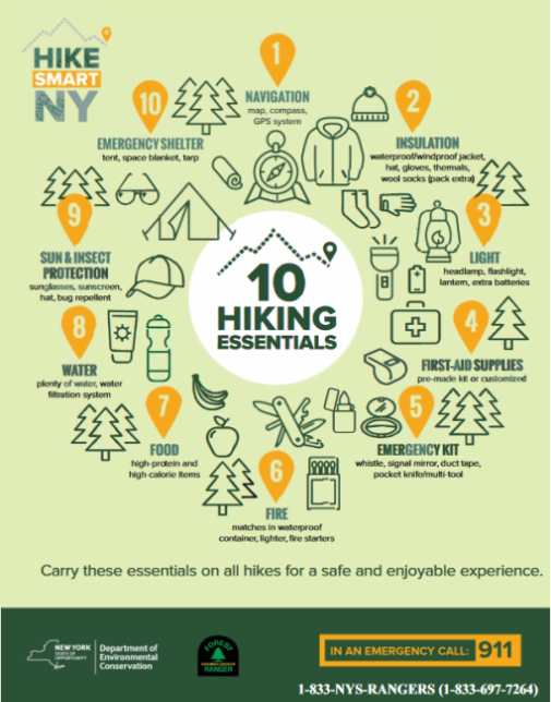
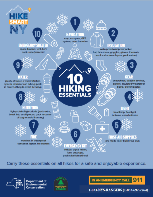
Woodstock is a beautiful and popular destination for enjoying the outdoors. Being prepared when you enter the wilderness, no matter how long you plan to be on the trail, is essential in the event something goes wrong. In the event of an emergency on the trails, call 911. New York State Forest Rangers can be reached at: 833-697-7264.
When venturing into the outdoors remember the 10 essentials:
- Navigation (map & compass, GPS)
- Insulation/Rain Gear
- Light (headlamp or flashlight w/ extra batteries)
- First Aid Supplies
- Emergency Kit (whistle, duct tape, pocket knife, etc)
- Fire (waterproof matches, lighter)
- Nutrition
- Water
- Sun and/or Insect Protection
- Emergency Shelter (tent, space blanket, or tarp)
Learn more about how to properly prepare to spend time in the wilderness by visiting HikeSmartNY dec.ny.gov/things-to-do/hiking/hike-smart-ny.
For more information on backcountry regulations in the Catskill Mountains, visit the NYSDEC Catskills Backcountry Information page dec.ny.gov/things-to-do/hiking/catskill-backcountry-information.
The files with the 10 Hiking Essentials and the 10 Hiking Essentials Winter are attached, in addition to the images being included.
Learn More
Climate Change in NY
How do we know we are experiencing climate change? Learn the facts and causes science.nasa.gov/climate-change/causes/.
- How has climate change affected New York state? dec.ny.gov/environmental-protection/climate-change/effects-impacts#:~:text=Overall%2C%20average%20annual%20precipitation%20has,storm%20events%20and%20heavier%20downpours.
- What are some solutions to climate change? drawdown.org/explorer
Climate Change in the Hudson Valley
The Hudson Valley is highly susceptible to the effects of climate change.
Learn more about how the natural resources and communities around you may be at risk by visiting the Ulster County Cornell Cooperative Extension webpage ulster.cce.cornell.edu/climate-change and the DEC fact sheet extapps.dec.ny.gov/docs/remediation_hudson_pdf/ccinthehvms.pdf on climate change in the Hudson Valley.
Learn more about the specific effects of climate change throughout the state by visiting this fact sheet extapps.dec.ny.gov/docs/administration_pdf/climatechangeimpacts.pdf.
Invasive Species and Climate Change
Invasive species and climate change are two major global environmental issues that are closely
interconnected. Climate change can create new habitats or alter existing ones, which can make it easier for invasive species to establish and spread. In turn, invasive species can exacerbate the impacts of climate change by altering ecosystems, reducing biodiversity, and damaging infrastructure.
For example, as temperatures warm, some invasive species that were once confined to tropical or subtropical regions may be able to survive and spread into new areas. This can lead to a loss of biodiversity, as native species are outcompeted for resources. Invasive species can also alter ecosystems by changing the frequency and intensity of fires, reducing soil quality, and impacting water resources. Moreover, invasive species can also contribute to climate change by releasing large amounts of carbon into the atmosphere. For instance, the invasive plant species known as purple loosestrife nyis.info/species/purple-loosestrife/ can cause significant carbon emissions by outcompeting native vegetation and reducing carbon sequestration.
Invasive Species in the Hudson Valley and Catskills Regions:
The Hudson Valley and Catskills regions of New York are home to several invasive species, which can cause harm to native ecosystems and biodiversity. Here are a few examples:
- Japanese Knotweed: Japanese Knotweed nyis.info/species/japanese-knotweed/ is a tall, fast-growing plant that can quickly overtake native vegetation. It forms dense thickets that can block waterways and alter the ecosystem. It is prevalent in the Hudson Valley and Catskills regions, and its control and removal can be challenging.
- Emerald Ash Borer: The Emerald Ash Borer nyis.info/species/emerald-ash-borer/ is a small, metallic green beetle that feeds on and kills ash trees. It is a significant threat to the ash tree population in the region, and efforts are underway to control its spread.
- Spotted Lanternfly: The Spotted Lanternfly nyis.info/species/spotted-lanternfly/ is an invasive insect that feeds on the sap of plants, causing damage to fruit trees, grapevines, and hardwood trees. It was first detected in the region in 2020 and is considered a significant threat to agriculture.
- Mile-a-Minute Vine: The Mile-a-Minute Vine nyis.info/wp-content/uploads/2024/06/mile-a-minute.webp is a fast-growing, invasive vine that can smother native vegetation and alter the ecosystem. It has spiky stems covered in barbs that can make it difficult to control and remove.
- Zebra Mussel: Zebra Mussels nyis.info/species/zebra-and-quagga-mussel/ are small, freshwater mollusks that can attach to and damage water infrastructure, boats, and other structures. They can also outcompete native species for resources and alter the ecosystem. They were first detected in the region in the early 2000s and have since spread to several waterways in the Hudson Valley and Catskills regions.
Efforts are underway to control and prevent the spread of these and other invasive species in the region. Community members can help by learning to identify invasive species, reporting sightings to local authorities, and taking steps to prevent the introduction and spread of invasive species, such as cleaning boats and equipment before entering waterways.
Resources:
- New York Invasive Species Information nyis.info/: This website provides comprehensive information about invasive species in New York, including identification, management, and prevention strategies. It also offers a variety of educational resources, such as videos, posters, and fact sheets.
- New York State Department of Environmental Conservation (DEC) dec.ny.gov/nature/invasive-species: The DEC is responsible for managing and protecting New York's natural resources, including invasive species. Their website offers a wealth of information about invasive species, including an identification guide, a list of prohibited and regulated species, and information about management and control.
- NY iMapInvasives nyimapinvasives.org/: This is an online mapping tool that allows users to report and track invasive species sightings. It is a collaborative effort between government agencies, non-profit organizations, and citizen scientists, and is designed to help identify and manage invasive species populations. Community members can use the tool to report invasive species sightings in their area and contribute to the overall effort to combat invasive species in New York.
- New York Natural Heritage Program (NYNHP) nynhp.org/: NYNHP works to facilitate the conservation of New York’s biodiversity by providing comprehensive information and scientific expertise on rare species and natural ecosystems to resource managers and other conservation partners.
- Catskill Regional Invasive Species Partnership (CRISP) catskillinvasives.com/: CRISP promotes education, prevention, early detection and control of invasive species to limit their impact on the ecosystems and economies of the Catskills.
Harmful Algal Blooms
Harmful Algal Blooms (HABs) are a serious environmental issue in New York, particularly in the summer months when temperatures are warm and water levels are low. HABs are caused by an overgrowth of cyanobacteria, also known as blue-green algae, which can produce toxins harmful to humans and animals. To view current and recent HABs in New York State visit NYHABS (arcgis.com) experience.arcgis.com/experience/e5dec19912454731a308bbb7af605fb3/.
HABs can occur in both freshwater and marine environments and can be triggered by a variety of factors, including warm water temperatures, excessive nutrients from sources such as agricultural and urban runoff, and changes in water chemistry. In the Hudson Valley and Catskills regions, HABs are often associated with nutrient pollution from agricultural runoff and sewage discharge, which can contribute to the growth of cyanobacteria.
HABs can have serious impacts on human and animal health. The toxins produced cyanobacteria can cause a range of symptoms, including skin irritation, nausea, vomiting, diarrhea, and even liver damage. In some cases, exposure to HABs can be fatal for pets and wildlife.
To address the issue of HABs in the Hudson Valley and Catskills regions, efforts are underway to reduce nutrient pollution, improve water quality monitoring and reporting, and develop early warning systems to alert the public to potential HAB outbreaks. Community members can also take steps to help prevent HABs by reducing their use of fertilizers and other sources of nutrient pollution and reporting suspected HABs to local authorities.
Resources:
- New York State Department of Environmental Conservation (DEC) dec.ny.gov/environmental-protection/water/water-quality/harmful-algal-blooms: The NYS DEC provides information on harmful algae blooms across the state. Their website includes updates on current blooms, health advisories, and information on how to report a bloom.
- New York State Department of Health (DOH) health.ny.gov/environmental/water/drinking/bluegreenalgae/: The DOH oversees the health, safety, and well being of New Yorkers by utilizing new developments in science as critical tools in the prevention and treatment of infectious diseases.
- The New York State Federation of Lake Associations (NYS FOLA) nysfola.org/habs/: NYSFOLA is a not-for-profit coalition of lake associations, individuals, and corporate members dedicated to the protection and restoration of New York lakes.
- Hudson River Watershed Alliance hudsonwatershed.org/: The Hudson River Watershed Alliance is a network of organizations and individuals working to protect the Hudson River and its watershed. Their website includes information on harmful algae blooms, including resources for prevention and management.
- The United State Environmental Protection Agency (EPA) epa.gov/habs: The mission of EPA is to protect human health and the environment by providing accurate scientific information.
Flooding
Increased oceanic and atmospheric temperatures residents will encounter increased precipitation, heatwaves, and extreme flood events. All residents should be aware of risks and know how to find information and help when flooding occurs. Whether you live in the flood zone or not, being prepared for an emergency is important. Visit this checklist health.ny.gov/publications/2802/ to find important information before you take steps to repair your flooded home.
For more information on how to prepare for a flood and what to do during one, visit the ready.gov/floods website. The Ashokan Stream Management Program also has their own Flood Emergency Preparedness fact sheet ashokanstreams.org/wp-content/uploads/2022/08/Stream-Guide-Flood-Emergency-Preparedness.pdf available online to learn more about floods and how you can best prepare.
Do not travel during flooding unless absolutely necessary. Six inches of moving water can knock a person down, and one foot of moving water can sweep a vehicle away. Do not drive through flooded water over roadways. Culverts and roads may be washed away leaving deep holes beneath standing water. Active electrical lines may be underneath standing water and can be deadly. Turn around, don’t drown.
Flood Risk:
Visit FEMA's Flood Map Service Center msc.fema.gov/portal/home to know types of flood risk in your area. The Emergency Alert System (EAS) and National Oceanic and Atmospheric Administration (NOAA) Weather Radio also provide emergency alerts.
Read A Homeowner’s Guide to Assessing and Mitigating Flood Risk ashokanstreams.org/wp-content/uploads/2023/12/AWSMP-Stream-Guide-Homeowners-Guide-to-Mitigating-Flood-Risk.pdf from the Ashokan Watershed Stream Management Program to learn how to flood proof your property and about local resources available. Funding may be available for certain flood mitigation solutions for those that reside within the NYC Water Supply, for more information visit the Catskill Watershed Corporation website cwconline.org/programs/flood-hazard-mitigation/.
View your location relative to flood zones on maps published by FEMA. Enter your address in the Ulster County Parcel Viewer gis.ulstercountyny.gov/parcel-viewer/ and under the heading ‘Map Layers – Water Resources’ click the button for ‘FEMA Adopted Flood Hazards.’ The map shows different types of flood zones based on the type of flood hazard expected. The Special Flood Hazard Area (SFHA) is sometimes inaccurately called the ‘100-year floodplain.’ The more accurate term is the 1% annual chance flood zone because there is a 1% chance of this area being flood every year, even if there was a large flood the previous year. A home within the SFHA has at least a 26% chance of being flooded over the life of your 30-year mortgage. Structures within this zone may also be at risk during shallower and more frequent floods.
For owners and managers of public river access sites, visit the NYS DEC’s Flood Resiliency Handbook extapps.dec.ny.gov/docs/remediation_hudson_pdf/hrefldhndbk.pdf for guidelines to reduce damage, costs, and other consequences associated with the effects of climate change, and begin planning for resilience.
Flood Insurance:
Homeowner’s insurance policies typically do NOT cover flooding. To secure a federally backed mortgages, homes within the SFHA must have an active flood insurance policy. However, a percentage of flood insurance claims come from outside the SFHA. Therefore it is recommended that residents in flood-prone areas outside the boundaries of the SFHA purchase a flood insurance policy. Policies typically go into effect 30 days after purchase. Get flood coverage under the National Flood Insurance Program (NFIP) fema.gov/flood-insurance or through a private company.
For information and resources related to repairing your flooded home, visit Health.ny.gov health.ny.gov/publications/2802/.
Post Flood Resources:
MyCoast NY mycoast.org/ny is a statewide portal used to collect and analyze photos of flooding, storm damage, and coastal change. When a photo report is submitted, it is automatically linked to data from the closest weather, river, and tidal or lake monitoring station to help provide context to the photo. The photo and accompanying data are then posted to the publicly accessible website. Photo reports can be submitted through the MyCoastNY app (iPhone apps.apple.com/us/app/mycoast-org/id939770387 / Android play.google.com/store/apps/details?id=org.mycoast.mobile&hl=en) or the website mycoast.org/ny with a registered account. The three photo report types are:
- Flood Watch mycoast.org/ny/flood-watch: Tracking flooding across the state. This includes inland and coastal flooding.
- Storm Reporter mycoast.org/ny/storm: Documenting storm damage across the state.
- Coast Snap mycoast.org/ny/coastsnap/about: Capturing the changing shoreline- currently at three locations.
Use MyCoast as a repository for photos of flood and storm impacts that can help raise awareness, build political will, inform municipal planning and emergency management, and complement other data and mapping. MyCoast brings together community members, local officials, state agencies, researchers, and NGOs in sharing and using the information.
To learn more about MyCoast NY, contact Jessica Kuonen at jak546@cornell.edu or access the MyCoast NY Contact page at mycoast.org/contact-us.

Get Involved: How Can I Help?
Visit the Environmental Protection Agency’s (EPA) webpage epa.gov/climate-change/what-you-can-do-about-climate-change for more information on what you can do to help.
This project was made possible by a program of Cornell Cooperative Extension Ulster County ulster.cce.cornell.edu/ in partnership with the NYS DEC Hudson River Estuary Program dec.ny.gov/nature/waterbodies/oceans-estuaries/hudson-river-estuary-program, NY Water Resources Institute and Cornell University cals.cornell.edu/water-resources-institute with support from the NYS Environmental Protection Fund. For more information, visit the Climate Resilience Partnership (CRP) webpage climateresiliencepartnership.org/.